Risk Manager
OCIANA®: Predictability in a Sea of Uncertainty
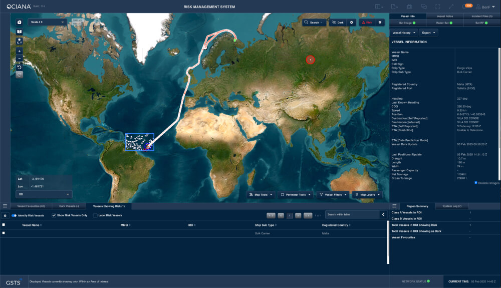
OCIANA®provides comprehensive, real time global maritime risk and compliance management, encompassing risk assessment, reporting, mitigation and response strategies.


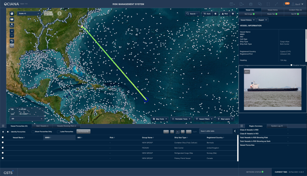
Situational Awareness Display and Common Operating Picture
Multiple sensor data sources aggregated to provide a single picture
EEZ monitoring
Awareness in remote regions where sensor coverage is minimal
Data agnostic – can integrate own data sets
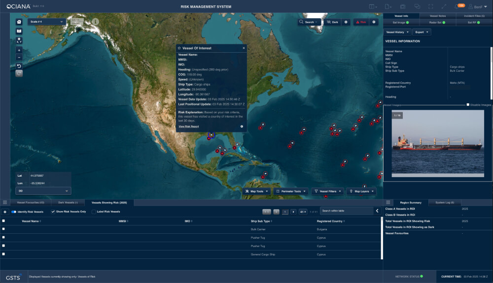
Risk Detection
Performs continuous data fusion and pattern-of-life analysis
Detects and mitigates against a multitude of risks including, Dark Vessels, Identity Spoofing, Sanctions Infractions, Trafficking, and Illegal Fishing
Provides customised alerts and notifications to support real time threat detection and monitoring
Detection of unusual vessel behavior to ensure safety and security of territorial waters
Advanced Vessel Identification (AVI) Toolkit
Enables detection of vessels that have misrepresented their identities, locations or intentions to ascertain associated risks and illegal activities
Tools for integrity analysis of selected group of vessels to determine patterns of behaviour and movement, utilizing live data and trained machine learning models
Intuitive user interface facilitates detailed analyses and verification of vessel identity, specifications status, and trajectory, all within a single interactive platform
Dashboard designed to revolutionize maritime risk management through the integration of AVI technology which provides users with real-time access to AVI predictions for 60K+ vessels
Intelligent Geofencing
Geofences enhanced with machine learning to deliver a high accuracy timeline and enhanced predictability
Provides real-time alerts and notifications
Enables monitoring of selected zones, vessels, protected zones, and high-value undersea assets
Vessel Path Prediction
Anticipates vessel location 10 days in advance which facilitates different applications such as planned interdictions of vessels conducting illegal activities as well as planned training exercises
Facilitates resource estimation and traffic management at ports
Enables continuous vessel monitoring and commercial and security risk analysis
Vessel Moving Haven
Perimeter tool that allows a user to monitor a region in a similar manner as a geofence
Moving haven perimeter can be along a path that either follows a vessel or pre-determined by set way points
Designed to allow movement along a path for a vessel that may not be currently sending AIS messages, or not at the frequency desired for updated movements (moving haven path need not be related in any way to a vessel’s actual movement)
Enables alerts for vessels based on speed, if a vessel goes dark, and perimeter entry and exit
Historical Reporting and Analysis
Ability to analyze past traffic in selected areas for future planning
Facilitate investigation of vessel movements towards environmental or other legal compliance
Pattern of Life Analysis
Persistent global threat and risk assessment based on dynamic real time vessel behavior analysis
Determines security risks based on intelligence gathered from multiple sensor systems
Facilitates predictive and real time analysis, providing insights prior to potential issues
Availability of Port Inspection data for integration into existing UI
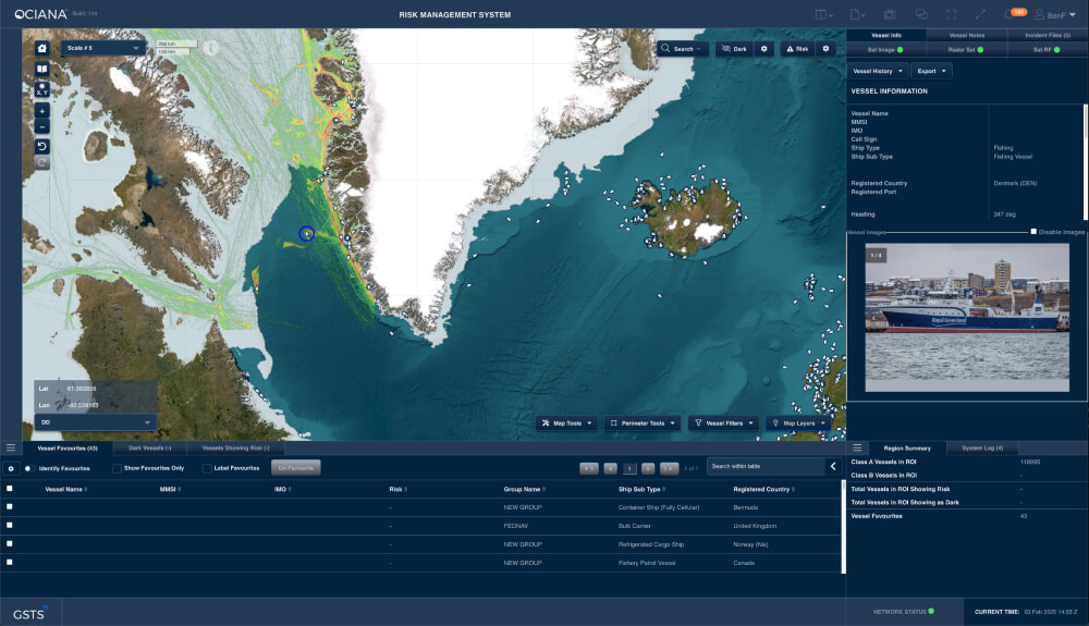
Arctic Surveillance
Provides persistent monitoring of large geographical regions to maintain visibility and respond in a timely manner to assert national sovereignty
Inter-agency Communication and Collaboration
Provides a common operating picture for all relevant organisations to have the same information, thus enabling collaborative planning and sharing of events to coordinate responses
Advanced chat features and ability to share incident files to facilitate inter-departmental communication
- Real time visibility
- Enhanced predictability
- Integrated inter-modal operations
Accelerate Your Maritime Business Today with AI-Powered Intelligence