The 2022 Atlantic hurricane season was destructive, even though it had an average number of named storms (14), a slightly above-average number of hurricanes (8), a slightly below-average number of major hurricanes (2), and a slightly below-average accumulated cyclone energy (ACE) index score. Despite this, it became the third costliest Atlantic hurricane season on record, behind only 2017 and 2005, mostly due to Hurricane Ian.
Hurricanes Fiona and Ian both left devastating damage on specific regions, with their effects reaching historical proportions. Fiona’s devastating aftermath resulted in damages amounting to billions of dollars in Puerto Rico, followed by its formidable remnants hitting Nova Scotia as a potent extratropical cyclone. This event marked the most financially impactful weather disaster ever recorded in Atlantic Canada. Meanwhile, Ian etched its own legacy by becoming the most expensive hurricane in Florida’s history and securing the third position among the costliest hurricanes ever recorded in the United States, standing only behind the catastrophic Hurricane Katrina in 2005 and the impactful Hurricane Harvey in 2017.
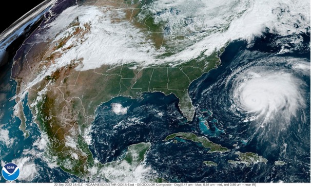
Hurricane Fiona transitioned into an extratropical cyclone and made landfall near Whitehead, Nova Scotia, on September 24 with hurricane-force winds. With maximum sustained winds reaching around 105 mph (169 km/h), equivalent to a Category 2 hurricane on the Saffir-Simpson scale, it became the strongest storm in Canadian history in terms of barometric pressure.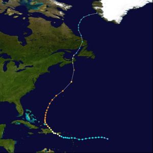 An unofficial measurement of 932.7 mbar (hPa; 27.54 inHg) on Hart Island set a new record for the lowest pressure ever recorded for a cyclone making landfall in Canada, potentially lower than any measurement along the eastern Northern America coast except the U.S. Gulf Coast. Other stations also documented pressures below the previous record of 940.2 mbar (27.76 inHg). Notable peak wind gusts included 111 mph (179 km/h) in Arisaig, Nova Scotia, and 110 mph (180 km/h) in Wreckhouse, Newfoundland and Labrador. Fiona generated substantial waves and destructive storm surge, with significant wave heights reaching up to 98 feet (30 m) east of the storm’s center and average heights of 40-50 feet (12-15 m).
Fiona’s impact resulted in power outages for over 500,000 customers, affecting a majority of Nova Scotia and Prince Edward Island residents, with 80% and 95% of customers respectively left without power. Tragedies occurred as well, with three presumed or confirmed fatalities arising from the hurricane. The financial toll was substantial, 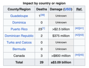 with insured losses in Canada estimated at a minimum of $1.07 billion CAD (equivalent to US$800 million). The overall damage is projected to be even higher. This event earned the unfortunate distinction of being the most expensive weather disaster in Atlantic Canada’s history and the seventh-costliest nationwide when adjusted for inflation.
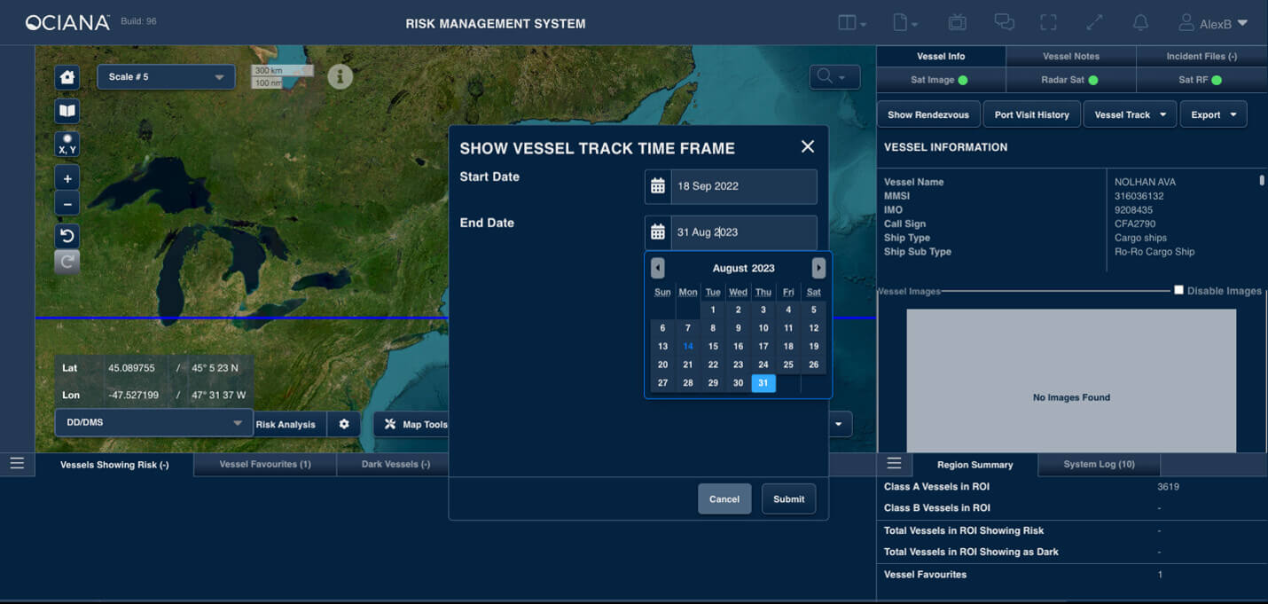
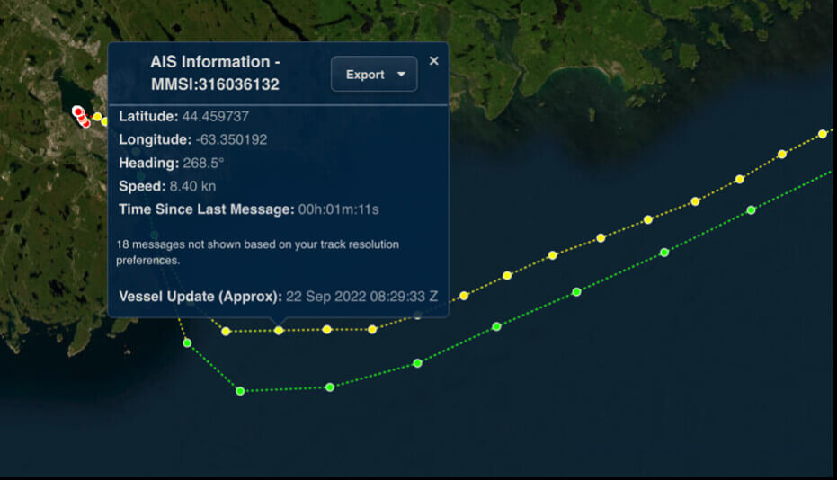
The following section will be an investigation on the impact of Hurricane Fiona on the maritime shipping industry, namely a cargo vessel named Nolhan Eva. Through the use of powerful OCIANATM API endpoints, we detected that the vessel was located in the Halifax harbour during the specified date of Hurricane Fiona’s landfall. Then through using GSTS OCIANATM application UI we were able to quickly display the vessel track for Nolhan Eva during the last two weeks of September 2022 as shown below.
The vessel track for the last two week of September for Nolhan Eva can be seen below and its regular route from Argentina, Newfoundland to Halifax, Nova Scotia.
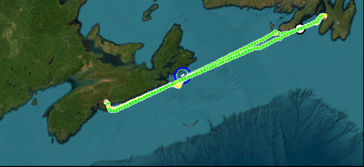
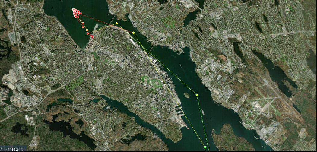
On September 22, at approximately 8:30 am Atlantic Time Nolhan Eva arrived at the entrance of the Halifax harbour and immediately put into the Fairview Cove container terminal to load and offload.
By 10:15 pm, September 22, Nolhan Eva was finished at the Fairview Cove container terminal and moved to an anchorage position in the Bedford Basin to weather the incoming intense extra-tropical system. It spent the following two and a half days waiting for the storm to pass prior to leaving the protection of the Halifax Harbour.
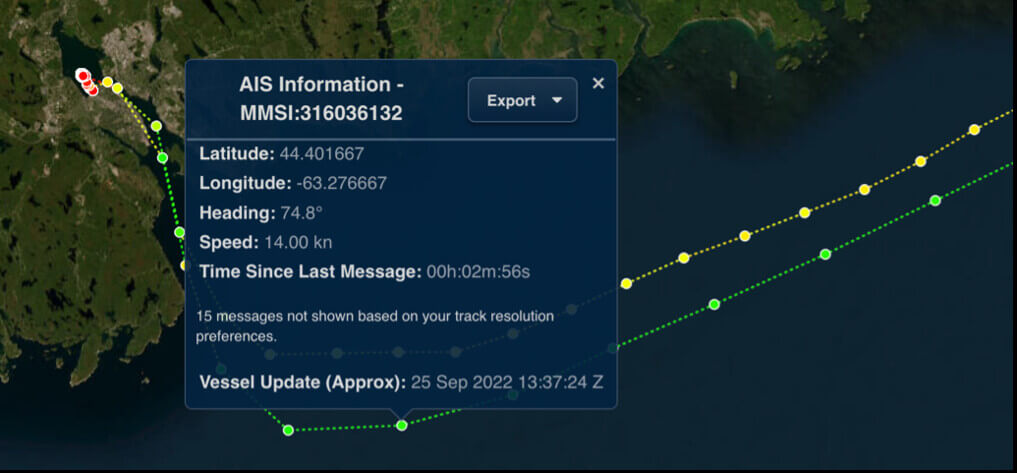
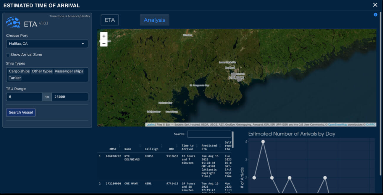
By mid-day of the 25th, Nolhan Eva pulled anchor and exited the Halifax harbour and began its journey back to Newfoundland. As a result of Hurricane Fiona, the cargo ship was delayed roughly two days while calling the Port of Halifax. However, with the use of OCIANATM , ports can minimize the impact of such delays. Port operators can manage and optimize vessels at berth and at anchor via the ETA Toolkit (see image below) allowing them to better plan for incoming vessels. Thus, allowing them to help to minimize the risk facing vessels by increasingly powerful storms such as Hurricane Fiona.
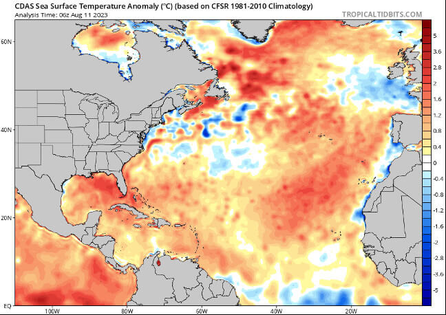
At present, National Ocean and Atmospheric Administration (NOAA’s) Climate Prediction Center’s recent El Niño-Southern Oscillation (ENSO) diagnostic discussion synopsis indicates a probability exceeding 95% that El Nino will persist into the Northern Hemisphere winter. Typically, El Nino leads to atmospheric conditions that mitigate tropical activity in the Atlantic hurricane season. However, the emergence of these dampening conditions has been delayed, and climate experts predict that the usual effects curbing tropical cyclone activity might not be prevalent for a significant portion of the remaining hurricane season.
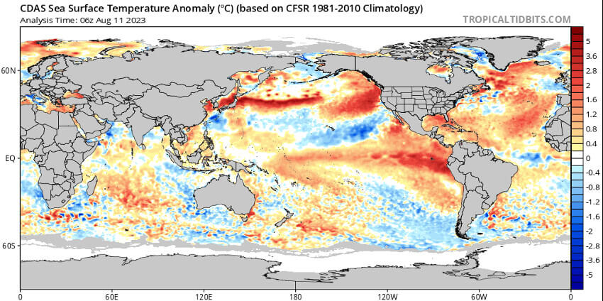
NOAA’s Climate Prediction Center has as of August 10th, revised their prediction for the 2023 Atlantic hurricane season, now expecting above-normal activity instead of near-normal activity.
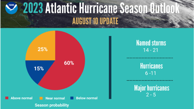
This change in forecast is attributed to exceptionally warm Atlantic sea surface temperatures countering the usual atmospheric conditions linked to the El Nino event. The likelihood of an above-normal season has been raised to 60% (up from the initial 30% forecast in May), while the likelihood of near-normal activity has decreased to 25% (previously 40%). The chance of a below-normal season is now at 15%. The updated outlook for the entire season anticipates 14-21 named storms, of which 6-11 could develop into hurricanes, and 2-5 of those could become major hurricanes. These ranges come with a 70% confidence level and encompass storms that have already formed this season.
Matthew Rosencrans, the lead forecaster for the hurricane season at NOAA’s Climate Prediction Center stated that a below-normal wind shear forecast, slightly below-normal Atlantic trade winds and a near- or above-normal West African Monsoon were also key factors in shaping this updated seasonal forecast.
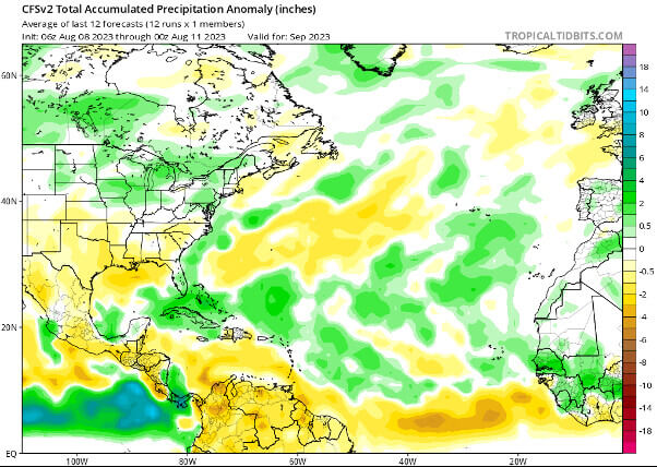
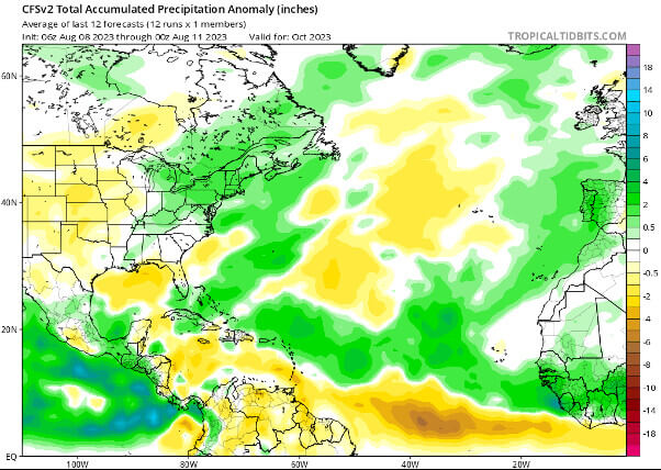
As shown above and below in the CFSv2 total accumulated precipitation anomaly charts for September and October, there is significantly above average precipitation throughout the main development region and off the east coast of North America indicating increased likelihood of tropical activity during the peak months of the hurricane season. Additionally, during October the model is showing well above precipitation surrounding Nova Scotia and Atlantic Canada, while this can often be due to coastal storms that begin during the fall, the clear connected track from the main development region indicates that tropical origin should not be ruled out.