Monitoring illegal fishing has long been one of the greatest challenges in ocean conservation. Vast, remote waters make it easy for vessels to operate without oversight, especially those that disable tracking systems to evade detection — the so-called dark vessels. But a groundbreaking new study in the journal Science, which analyzed activity across 1,380 fully and highly protected Marine Protected Areas (MPAs), is the first to demonstrate that strong legal protections truly work — and that dark vessel detection technology can finally validate compliance.
Using a combination of Synthetic Aperture Radar (SAR) imagery, Automatic Identification System (AIS) data, and AI models developed by Global Fishing Watch, scientists identified fishing vessels over 15 meters long, including those intentionally operating without broadcasting their locations.
Surprising study results
The findings from the peer-reviewed research are striking. More than 78% of MPAs showed no industrial fishing activity at all, and among the areas where fishing was detected, 82% recorded less than 24 hours of activity per year.
Strongly protected MPAs had nine times fewer vessels per square kilometer than unprotected coastal waters. Only a handful of large, well-known MPAs — such as the Chagos Marine Reserve and Australia’s Great Barrier Reef Marine Park — showed significant activity, around 900 hours annually, highlighting areas where enforcement remains critical.
Need for multiple datasets
A major insight from the study is the need to use multiple data sources. AIS alone missed nearly 90% of vessels detected by satellite radar within these protected areas.
Each dataset has blind spots: AIS is easy to disable, while SAR cannot identify ships by name. When combined with AI, however, they offer a near-complete view of industrial fishing activity — including dark vessels previously invisible to authorities.
Researchers emphasize that this technological leap has real-world benefits. Strictly protected MPAs support healthier ecosystems, greater fish abundance, and increased spillovers into surrounding fisheries, boosting catches and strengthening coastal economies.
But these benefits only materialize when protections are respected. With advanced satellite surveillance, countries can target patrols more effectively and dramatically reduce the cost and complexity of enforcement.
Ultimately, the study confirms a powerful truth: when countries establish strong MPAs and have the tools like dark vessel detection technology to monitor them, illegal fishing drops dramatically.
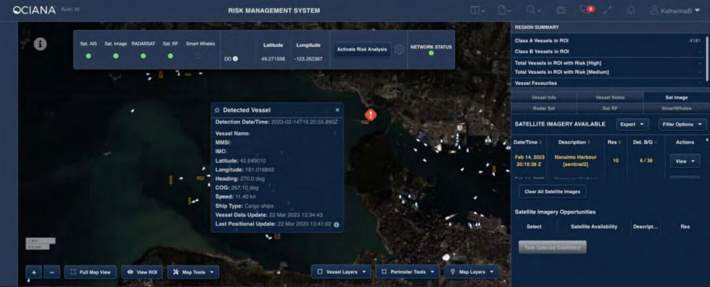
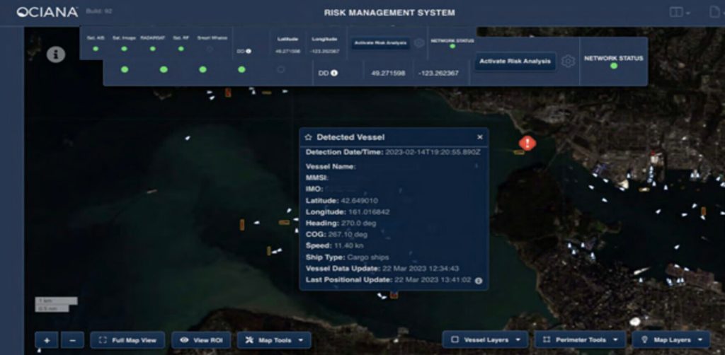
Dark vessel detection technology in OCIANA®
GSTS has developed a dark vessel detection capability within its OCIANA® platform to help organizations worldwide better monitor large ocean areas. It ingests and processes a variety of earth observation satellite data (radar and optical), simultaneously with other data sets describing ocean conditions, weather, port activity, vessel history, and global-scale satellite AIS vessel information.
When combined with deep learning models, geospatial analysis, and bespoke analytics, OCIANA® can flag suspicious vessels that may have turned off their AIS transponder or altered information about the vessel, voyage or intentions.
Monitoring illegal activities in real-time
OCIANA’s dark vessel detection technology can also be used to anticipate suspicious activities. For example, if a vessel is detected moving towards a high-risk area, such as a known piracy hotspot, it can alert maritime authorities to investigate further.
Another key advantage of dark vessel detection technology is cost savings. Solutions like OCIANA® leverage existing data sources, such as satellite imagery and AIS data, rather than requiring entirely new, expensive data-acquisition systems. It also reduces the costs of regularly dispatching ships, aircraft, or drones to cover vast maritime zones. Once a suspicious vessel or dark behaviour is flagged, enforcement assets can be deployed only when needed.
Enhancing sovereignty and safety
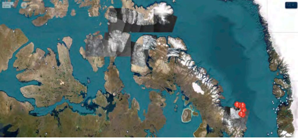
At the height of the COVID-19 pandemic in the summer of 2020, New Zealander Peter Smith set out to sail the notoriously treacherous Northwest Passage—a route that Canada had temporarily closed to all non-essential traffic to protect remote Indigenous communities with limited access to advanced healthcare.
Despite these restrictions, Smith pressed ahead aboard his 52-foot aluminum sailboat, Kiwi Roa, navigating one of the most isolated maritime corridors on the planet.
During the voyage, OCIANA® was able to track Kiwi Roa only intermittently, primarily when Smith activated the vessel’s AIS-B transponder. These brief signals allowed the platform to plot segments of his route, providing occasional visibility into his progress through the ice-choked waters. However, for much of the journey, Kiwi Roa sailed as a “dark vessel,” leaving authorities with little insight into its exact location.
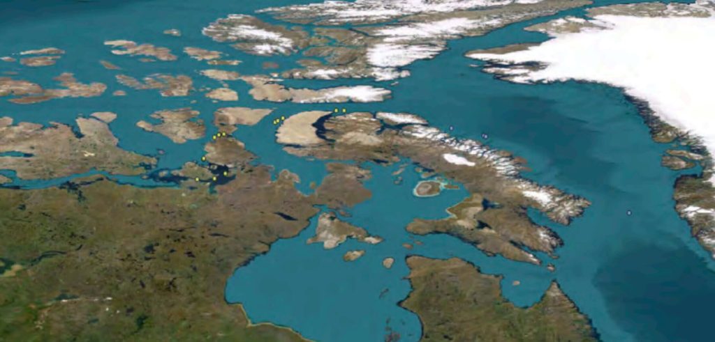
This lack of situational awareness posed a significant risk—not just from a public health standpoint, but also from a search-and-rescue (SAR) perspective. The Arctic’s harsh environment affords little margin for error, and the nearest SAR resources were located more than 1,200 nautical miles to the south in Winnipeg.
Although Smith completed the voyage safely, the incident underscored the operational blind spots that occur when vessels travel without continuous tracking in remote regions.
Had an emergency occurred, rescue operations would have been slow, complex, and potentially life-threatening. The experience highlighted the critical importance of modern dark-vessel detection capabilities for safeguarding both national sovereignty and mariner safety in the Arctic.
Chokepoint surveillance
GSTS has enhanced its dark vessel detection technology to enable chokepoint surveillance (the monitoring of specific, critical points in a network or physical system to control and manage traffic or movement). Ship-sized objects are automatically detected from satellite imagery, and if no associated AIS track is found in the vicinity, an alert is sent to the operator.
Dark vessel detection can enhance a government’s maritime domain awareness by providing a truer representation of what is happening on the water. Vessels that don’t comply with AIS regulations can be identified and targeted for further investigation by other on-water and/or airborne surveillance assets.
In the Canadian Arctic, OCIANA® could form the backbone of an Arctic surveillance and SAR system, especially if updates to NORDREGS require the mandatory carriage of AIS-B by all vessels less than 300 tonnes.
As criminal activities such as smuggling, transshipment of embargoed goods, and the ongoing practice of trade with sanctioned countries continue, dark vessel detection technology has become an increasingly crucial tool for identifying vessels engaged in such activities.
Transshipment is a common problem in terms of sanctions busters skirting legitimate authorities by masquerading the origin of goods being sold, be it food, illegal arms, or ultimately oil.
Within the context of the Russian-Ukrainian conflict, oil is being transshipped to tankers under flags of convenience. The problem is not merely sanctions enforcement but also environmental protection. Most reputable shippers using reputable flags of registry replace their vessels every 15-20 years as both safety and hull integrity diminish over the course of merchant service.
During the last 18 months, there has been exponential growth in a “shadow fleet” to meet demand. Vessels that would normally be taken out of service are now being repurposed to perform dangerous transfers at sea, all the while being reflagged in countries with little to no safety standards, an enforcement regime, and, most importantly, without marine insurance. Therefore, when (not if) there is a maritime environmental disaster, there will be little recourse to recover cleanup costs.
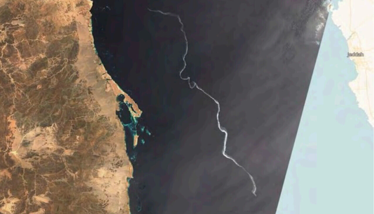 May 23, 2023 Oil Spill in the Red Sea as reported in Group Captain, a ship suspected of 150-Mile-Long Oil Slick in Red Sea. By combining AIS data with imagery, the list of culprits was narrowed down to three vessels.
OCIANA’s pattern-of-life analytics identify the activities vessels are engaged in by interpreting their kinetic signatures. These behavioural inferences can be combined with dark-vessel detection to highlight high-risk or anomalous movements associated with smuggling, illicit transshipment, and potential infrastructure sabotage.
The platform allows users to define surveillance areas and “keep-out” zones through configurable geofences, generating alerts when a suspect vessel enters, approaches, or is projected to cross into these areas.
Enforcement agencies can also leverage OCIANA’s ETA modelling, which predicts a target vessel’s arrival as far as 28 days in advance, enabling proactive planning and coordinated interdiction efforts.
Why choose OCIANA®
OCIANA® delivers an advanced dark vessel detection capability designed to help governments and maritime organizations monitor vast ocean areas with greater accuracy and efficiency.
The platform integrates multiple data sources—including Synthetic Aperture Radar (SAR), optical satellite imagery, AIS signals, ocean and weather data, vessel history, and port activity—to create a comprehensive and near–real-time picture of maritime activity.
By combining these datasets with deep learning models, geospatial analytics, and behaviour-based algorithms, OCIANA® can identify vessels that have turned off their AIS transponders, manipulated their identity, or are operating in ways that suggest illegal or high-risk behaviour.
A key advantage of OCIANA® is its ability to provide proactive surveillance. The system can alert authorities when vessels approach high-risk areas, enter protected zones, or display movement patterns associated with smuggling, transshipment of embargoed goods, illegal fishing, or infrastructure sabotage.
OCIANA® also supports chokepoint surveillance by automatically detecting ship-sized objects in satellite imagery and cross-referencing them with AIS tracks to highlight vessels that may be operating in the dark. These insights help authorities target their enforcement resources more effectively, reducing the need for costly and continuous in-person patrols by ships, aircraft, or drones.
The platform also enhances national sovereignty and safety in remote regions. In areas such as the Canadian Arctic, OCIANA®’s ability to track vessels, detect AIS gaps, and infer activities from kinetic signatures provides a backbone for improved maritime domain awareness and search-and-rescue readiness.
Beyond security, OCIANA® supports sanctions enforcement and environmental protection by identifying shadow-fleet vessels, monitoring high-risk oil transfers, and narrowing down contributors to pollution events through the fusion of AIS and satellite imagery.
Contact us to request a demo of OCIANA®.